
New York Mayor Bill de Blasio urged residents to stay home during the storm. In-person school will shift to fully remote on Monday, and Covid-19 vaccination appointments will be rescheduled, he said.
Overall, more than 110 million Americans will feel winter’s sting early this week as the nor’easter takes aim at the most densely populated cities along the East Coast.
Citing expected snow, high winds and coastal flooding, New York Gov. Andrew Cuomo on Sunday directed state agencies to mobilize emergency response resources.
New Jersey Gov. Phil Murphy declared a state of emergency starting at 7 p.m.
The Emergency Operations Center has been activated, and troopers are ready to assist as needed. Power outages are expected, and state authorities are in contact with utility companies on their storm preparations, said a news release from Murphy’s office.
State offices, Covid-19 vaccine “mega-sites” and most public transit will be closed Monday, the release said.
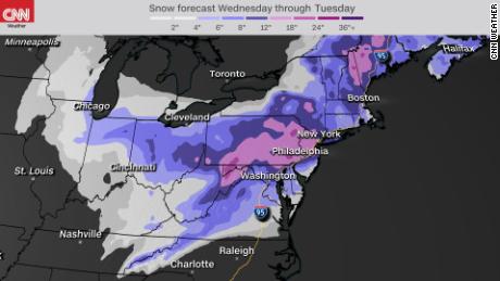
It’s been almost two years since Washington, DC, has had a snowfall greater than 1 inch, but that could change drastically by later Sunday. The city is under a winter storm warning through Sunday evening, with 4-8 inches of snow possible. Additional snow will likely fall on Monday.
“Forecasting snowfall amounts in the nation’s capital is rarely easy, but confidence is increasing that the DC area will see a significant snowfall developing on Sunday and lasting into Monday,” says CNN meteorologist Taylor Ward.
The storm could bring the nation’s capital as much as 10 inches of snow. This would end the 709-day streak that Washington, DC, has gone without a snowfall greater than 1 inch.
“The only other time this has happened was a 788-day streak that ended in 2013,” said CNN meteorologist Brandon Miller.
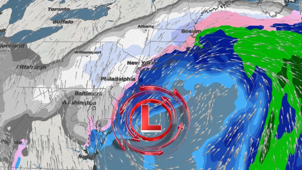
The storm’s path
On Sunday morning, more than 110 million people were under winter weather alerts from the southern Great Lakes to New England. The storm left heavy snow across northern Illinois and central Indiana, causing travel headaches.
The storm will strengthen into a powerful nor’easter by Monday morning as it reaches the coast. This will be a long duration event for many along the eastern seaboard as the system will be slow to exit.
Snow will fall in periodic bursts over the next three days from DC, Philadelphia, New York City to Boston, ending gradually from the southwest to the northeast.
Major impacts expected
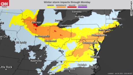
Strong winds will accompany the heavy snow, reducing visibility and causing power outages. Travel disruptions will be extensive from the ground to the air as the storm coats roads and runways with fresh snow.
Snowfall rates of 1-2 inches per hour were reported near Chicago’s suburbs late Saturday evening, where up to 9 inches of snow is forecast by Sunday night.
As the storm moves east, it will reorganize and intensify. The highest snow accumulations will occur from New Jersey to southern New York, eastern Pennsylvania and parts of Maryland, where up to a foot of snow is possible.
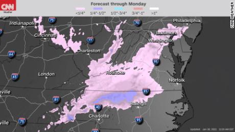
Ice and sleet accumulation is also a concern for portions of North Carolina, Virginia, Maryland and West Virginia. The highest totals will likely fall north of Charlotte and Raleigh where up to 1/2 inch of ice is possible.
The warm sector of this storm is creating numerous showers and embedded thunderstorms across the central and southeastern US today. Expect a rainy Sunday in Atlanta before showers exit the region by the start of the work week.
Areas farther west such as St. Louis and Springfield, Illinois, will see more of a rain/snow mix through Sunday evening. Exactly how much snow will stick to the ground remains uncertain.
One week after areas of Iowa were pummeled by snow, the Hawkeye State could see a few additional inches by Sunday night.
A developing nor’easter
Snow is expected to be widespread by late Sunday morning, according to the National Weather Service in Baltimore and Washington, DC. By Sunday afternoon into Monday, there is the potential of a changeover to sleet and freezing rain.
With any nor’easter, there is uncertainty in the forecast snow totals because so much depends on the exact track of the low pressure.
“There seems to be a consensus amongst forecast models that moderate to heavy snow will occur from portions of Virginia to Pennsylvania and New Jersey, but there continues to be some uncertainty on the exact track of the low pressure Monday into Tuesday,” Ward said.
“This will have a significant impact on how much snow falls from New York City into New England. A storm system that tracks parallel to the coast would provide greater snowfall, while a more eastward track out to sea would limit snow totals in New England.”
That could make the difference in places like Boston and New York City between seeing 4 inches of snow or a foot.
Philadelphia’s NWS office is forecasting more than 6 inches of snow with gusts of wind as high as 45 mph “creating significant blowing and drifting snow.”
CNN’s Laura Ly, Jennifer Gray and Ganesh Setty contributed to this report.
You may also like
-
UK coronavirus variant has been reported in 86 countries, WHO says
-
NASA technology can help save whale sharks says Australian marine biologist and ECOCEAN founder, Brad Norman
-
California Twentynine Palms: Explosives are missing from the nation’s largest Marine Corps base and an investigation is underway
-
Trump unhappy with his impeachment attorney’s performance, sources say
-
Lunar New Year 2021: Ushering in the Year of the Ox